| Egypt Map Contributor(s): National Geographic Maps (Author) |
|||
 |
ISBN: 1566955297 ISBN-13: 9781566955294 Publisher: National Geographic Maps
Binding Type: Folded Published: January 2019 Click for more in this series: Adventure Map (Numbered) |
||
| Additional Information |
| BISAC Categories: - Travel | Maps & Road Atlases (see Also Reference - Atlases, Gazetteers & Maps) - Travel | Middle East - Egypt - Travel | Special Interest - Adventure |
| Series: Adventure Map (Numbered) |
| Physical Information: 0.1" H x 9" W x 4.25" L (0.08 lbs) 2 pages |
| Features: Illustrated, Index, Maps, Price on Product |
| Descriptions, Reviews, Etc. |
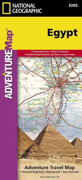
| Publisher Description: - Waterproof - Tear-Resistant - Travel Map Explore the extraordinary history and great mysteries of the cradle of civilization with National Geographic's Egypt Adventure Map. This expertly crafted map provides global travelers with the perfect combination of detail and perspective, highlighting hundreds of points of interest and the diverse and unique destinations within the country. Cities and towns are clearly indicated and easy to find in the user-friendly index. A road network complete with distances and designations for roads, expressways, major routes, and secondary routes will help you find the route that's right for you. Transportation within and beyond the country is made easier with the location of airports, airfields, railroads, ferry routes, harbors, border crossings, and police control points. In addition to typical sites of interest such as UNESCO sites, national parks, mosques, churches, and monuments, this map includes Egypt's many archeological sites, pyramids, oases, caves, and hot springs. Travelers wishing to recreate along the Mediterranean or Red Sea Riviera will find dozens of beaches, coral reefs, scenic viewpoints, and ship wrecks to explore.
Egypt's northern half is shown on the front side of the print map from its Mediterranean coast, Alexandria, and the great city of Cairo south to include the cities of Faiyum, Beni Suef, Minya, Asyut, and Sohag. The reverse side of the map covers the southern portion of the country, and shows the cities of Nag Hammadi, Luxor, Aswan, and Qena, and the oases of Kharga and Dakhla. From the Nile River's fertile valley, the world's first great civilization arose in Egypt over 4,000 years ago. Today, Egypt is Africa's second most populous country and its capital Cairo is the largest city in the Middle East and Africa with over 11 million inhabitants. The country is defined by the Nile ? the longest river on Earth ? and the vast, surrounding deserts that are home to the nomadic Bedouins. Travelers from around the world are drawn to the awe-inspiring Pyramids and Great Sphinx at Giza and relaxing along the beaches of the Sinai Peninsula and Gulf of Aqaba. Every Adventure Map is printed on durable synthetic paper, making them waterproof, tear-resistant and tough -- capable of withstanding the rigors of international travel.
|
Contributor Bio(s): National Geographic Maps - Adventure: - Founded in 1915 as the Cartographic Group, the first division of National Geographic, National Geographic Maps has been responsible for illustrating the world around us through the art and science of mapmaking.Today, National Geographic Maps continues this mission by creating the world's best wall maps, recreation maps, atlases, and globes which inspire people to care about and explore their world. |
| Customer ReviewsSubmit your own review |
| To tell a friend about this book, you must Sign In First! |
Copyright © 2024 TheReadingWarehouse.com